Legal Land Descriptions
| Section | Basic unit of the system, a square tract of line
one mile by one mile containing 640 acres.
|
| Township | 36 sections arranged in a 6 by 6 array, measuring
6 miles by 6 miles. Sections are numbered beginning with the
northeast-most section, proceeding west to 6, then south along the west
edge of the township and to the east.
|
| Range | Assigned to a township by
measuring east or west of a Principal Meridian
|
| Range Lines | North to south lines which mark township
boundaries
|
| Township Lines | East to west lines which mark township boundaries
|
| Principal Meridian | Reference or beginning point for measuring east or west ranges. |
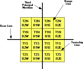
| The largest grouping is the township which is named in reference to a Principal Meridian (P.M.) and a Baseline. T2N, R1E refers to Township 2 North (of the Baseline), Range 1 East (of the Principal Meridian). |
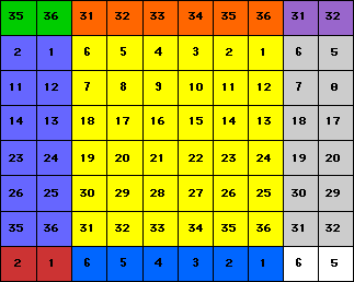
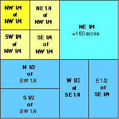
Within each township are 36 sections, each one mile square. Each section contains 640 acres. The sections are numbered from 1 to 36 in the following order. Each individual section can then be divided into quarters or portions of quarters.
The largest grouping is the township which is named in reference to a Principal Meridian (P.M.) and a Baseline. T2N, R1E refers to Township 2 North (of the Baseline), Range 1 East (of the Principal Meridian).
![]()
Information obtained from:
outfitters.com/genealogy/land/land.html